Around and Beyond the Dolomites
Chasing the perfect trail (cont'd III)
I have been doing a full week of trail running across the mountains in the last three years always at the end of the summer. It’s like meditation for me and helps me to switch off from work, so I wanted to do this again in 2020, but two things were very different this year:
First, there is Covid-19, which made it very hard to plan in advance, especially if you have to book a hotel at 6–7 different locations, so we decided to stay in one place this year — in Cortina d’Ampezzo in the heart of the Italian Dolomites.
Second, I was injured for a long time this year. I had a hernia in March (I just got it fixed a couple of days ago), and I had problems with my calves for 3–4 months that stopped me entirely from running, so I was very untrained. Therefore, we decided to do more hiking, climbing, and Via Ferratas (Klettersteig) rather than trail running. You will notice this also at the unusual low distance of our tours compared to the years before. Special thanks to Lucas and Christian, who were trained much better than me but took it a bit slower than usual.
Please, don’t try to do this without proper training, planning, equipment, etc. but feel free to ask me any question about the trip.
Equipment
The equipment was very similar compared to the last years, as you can see in the picture below (pic from 2019, from 2018, from 2017). It still amazes me how durable all my running clothes are after all these intense trips — I took precisely the same clothes as in the previous years except a new pair of shoes, my climbing set (Klettersteigset), and a new book. Let’s go.
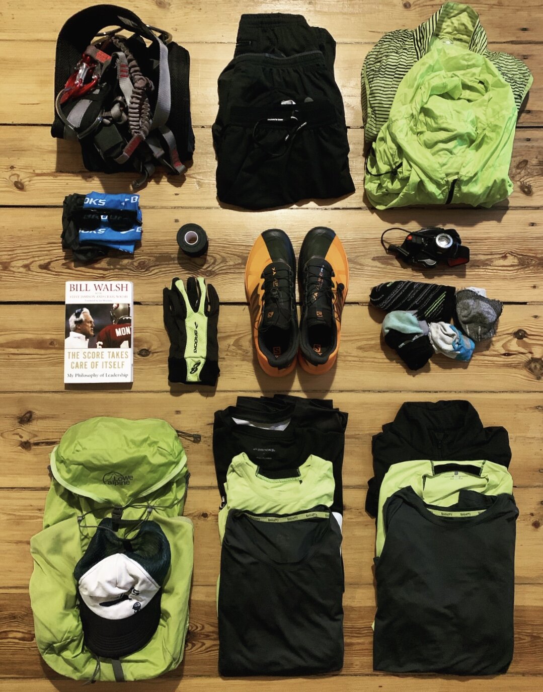
All the equipment for our activities
The route and the journey
I went to Munich by train on a Friday, and we started driving to Italy on Saturday morning at around 8.00 am. Christoph and I picked up Lucas in Kufstein (Austria) from where we continued our drive to Italy. Since it was still early in the day, we decided to do a small tour before heading to our hotel in Cortina d’Ampezzo in North Italy.
Day 1: 14km, 2:45h, 930hm — Monte Piana.
Komoot was our best friend during this trip, and we found a nice hike up to Monte Piana. Unfortunately, as soon as we left the car at the parking lot (Parkplatz Drei Zinnenblick), it started to rain. That meant we were wet from the get-go — a great start. We hiked up a small river from where a strong ascent started — from 1600hm to 2200hm.

Lucas trying to spot the summit
Nearly on top of the mountain, we discovered the first tunnels that got built during the First World War when Italy fought against Austria. We were too curious to see what’s inside, so we went into one of the tunnels for 200–300m until it got too hard to continue, so we went out again. Crazy that people built these tunnels more than 100 years ago in the middle of the mountain.

One of many tunnels
We went further up the last meters until we reached the top of Monte Piana (2324m), where we discovered many more remnants from the battles that took place on Monte Piana. Usually, you can see lots of other summits from the top, but due to the rain, we saw only clouds around us. A view we know just too well from the last years. We went down Monte Piana on the other side until we reached Dürensee, from which it was only 10min back to our car. We got changed outside, drove to our hotel where we stayed for the next five days, and planned the other tours for the rest of the week.

Down to the Dürensee
Day 2: 23km, 5h, 1500hm — Pomagagnong.
Due to Covid-19, there was no breakfast buffet, and it took quite long until we all got our breakfast. Lucas even tested the patience of other hotel guests during the breakfast quite a bit with all the stuff he ordered. Since it rained the whole night like crazy, we couldn’t do the tour we initially planned since it would have been too dangerous to climb on wet stones, and we decided to wait a bit until it might stop raining. Again, we used Komoot to create our tour spontaneously to Pomagagnong, a mountain just in front of Cortina d’Ampezzo, and started in the late morning. We were lucky, and only after 30min when we went out, the rain stopped. We hiked up some very steep parts and a short via Ferrata and arrived at Punta Erbing (2301m).

Via Ferrata to Punta Erbing
From there, we continued along the ridge towards Rifugio Son Forca. From time to time, the fog went away, and we could see parts of Cortina d’Ampezzo and a few other summits — a glimpse of how beautiful it can look like if there are no clouds. We crossed a few ski pistes and went back to where the steep ascent started and then pretty fast down where we chilled a bit near the river eating local cheese and bread before heading back to the hotel.
Day 3: 20km, 8h, 2000hm — Tofana di Mezzo.
Same procedure as every day — we were looking at the weather forecast, but on that day, it didn’t look too shabby, so we decided to go up to Tofana di Mezzo (3242m).

View towards Cortina d’Ampeezo and Rifugio Pomedes
After breakfast, we drove to our starting point, from which we hiked up to Rifugio Dibona. Due to all the rain in the days before, it was still quite slippery and wet. After arriving at the Rifugio Dibona, we went further up to Rifugio Pomedes from where the Ferrata Olivieria started at 2450m. We put on our climbing set and climbed up to Punta Anna (2837m) — which was partially quite tricky and steep (some people call it Superferrata given how long it is).

Can you spot me?
The more we climbed up, the worse the weather got, unfortunately, and suddenly, it started to hail a bit. Punta Anna was not our final destination, though, and we needed to hike further and climb up to Tofana di Mezzo (3242m). The hail turned into snow, and suddenly, we heard a thunderstorm that luckily didn’t come back again. After reaching the summit, we went down as fast as possible to get warm again. I also needed to hop on a deal flow call, and we arrived at Rifugio Lagazuoi (2778m) from where I joined the call.

Most difficult part of the Via Ferrata
After one hour and getting a bit cold, we went back outside into the snow and ran down to Rifugio Pomedes, then to Rifugio Dibona and to our car. Boy, we were pretty cold even after going into the car and changing clothes, and it took a shower and much more time until we finally got warm again.
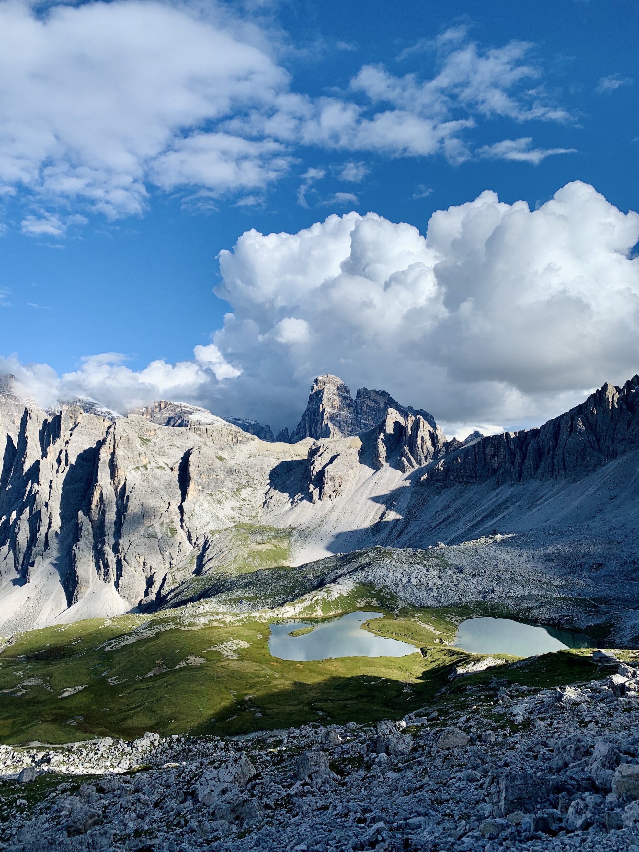
Day 4: 26km, 9h, 1600hm — Tre Cime di Lavaredo (Drei Zinnen).
The fourth day was supposed to be the highlight of our tour since we planned to go to Tre Cime di Lavaredo and to climb up to the “big peak” (Große Zinne, 2999m). We drove just near Lago di Misurina from where we hiked up to the Auronzohütte, where most of the people usually park their car and start the tour.

“Drei Zinnen” as seen from one of the tunnels
It took us a few minutes to find the small path towards the Große Zinne, and we started the steep ascent. There was still quite some snow from the day before, so it was a bit slippery, but it also helped us to see where the path was due to our forerunners on that day.

View from the way up to Große Zinne
However, the more we climbed up, the more slippery it got, and we had little equipment with us. We stopped just a few 100 meters before the final summit because we thought it would have been too dangerous to continue climbing and so we went down the same way. We decided to use the time to hike around the Drei Zinnen and to climb up to Paternkofel (2744m). The way up to Paternkofel started again with a tunnel from the First World War from where we entered the Via Ferrata up to the peak. We went down the same way and continued to the Dreizinnenhütten through more tunnels. The sun was out, and the views were stunning, so we decided to climb up just another peak — the Toblinger Knoten. I’m a bit afraid of heights and the Via Ferrata has with several free-hanging ladders (see this video), which was honestly quite challenging for me, but I had no other choice than to follow the other two up the mountain.
View on the way down from Toblinger Knoten
The view from the Toblinger Knoten (2617m) is incredibly beautiful, though. We went down a different Via Ferrata, hiked back around the Drei Zinnen, and then back down to where we parked our car. We bought some Italian cheese and one kilo of Apfelstrudel that we ate at the beautiful Lago di Misurina before going to a restaurant for a “proper dinner.”
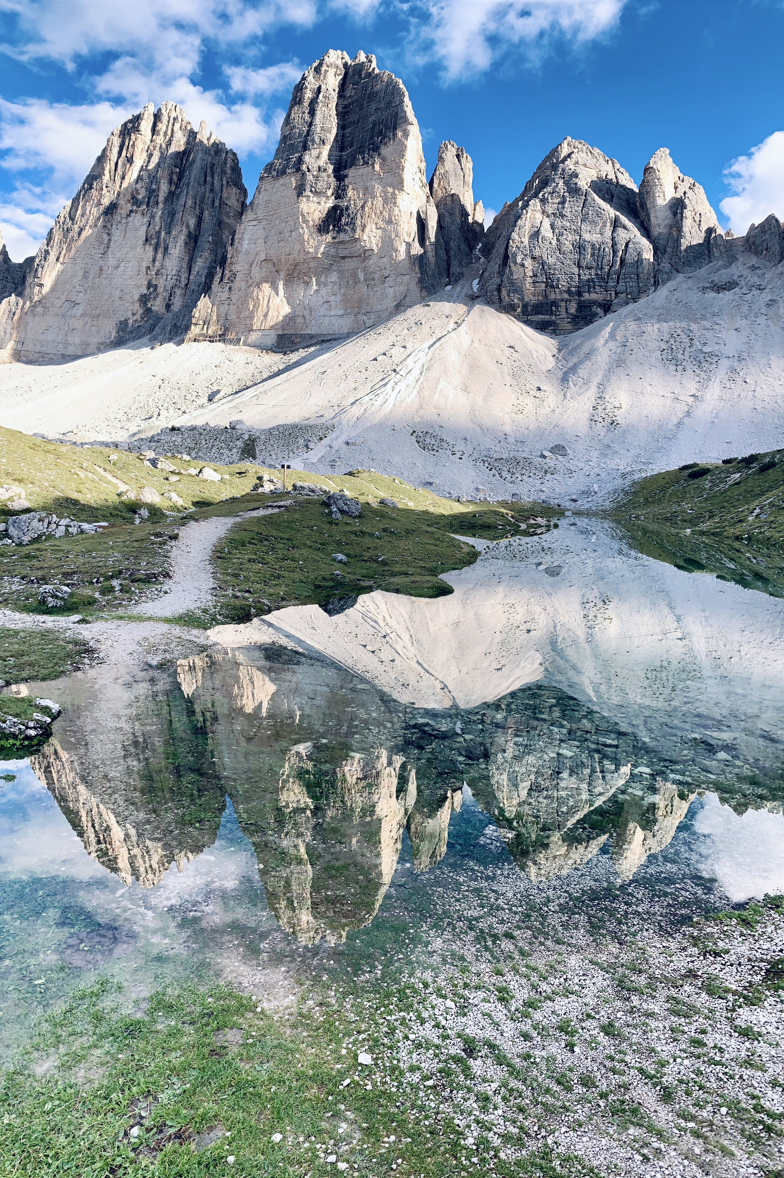
Drei Zinnen in one of the small mountain lakes
Day 5: 25km, 6.30h, 1700hm — Cinque Torri.
Unfortunately, it rained again, so we didn’t want to climb up Monte Cristallo (3221m) and decided for a more leisurely hike: Cinque Torri (2361m). We started at the same location as on the second day and hiked up very fast until we reached Cinque Torri. On top of Cinque Torri, we went to the Open Air Museum about the First World War that was quite interesting to learn more about all the brutal events that took place in these mountains. We spotted a lot of people climbing at the rocks nearby and continued towards Lago Bai de Dones.
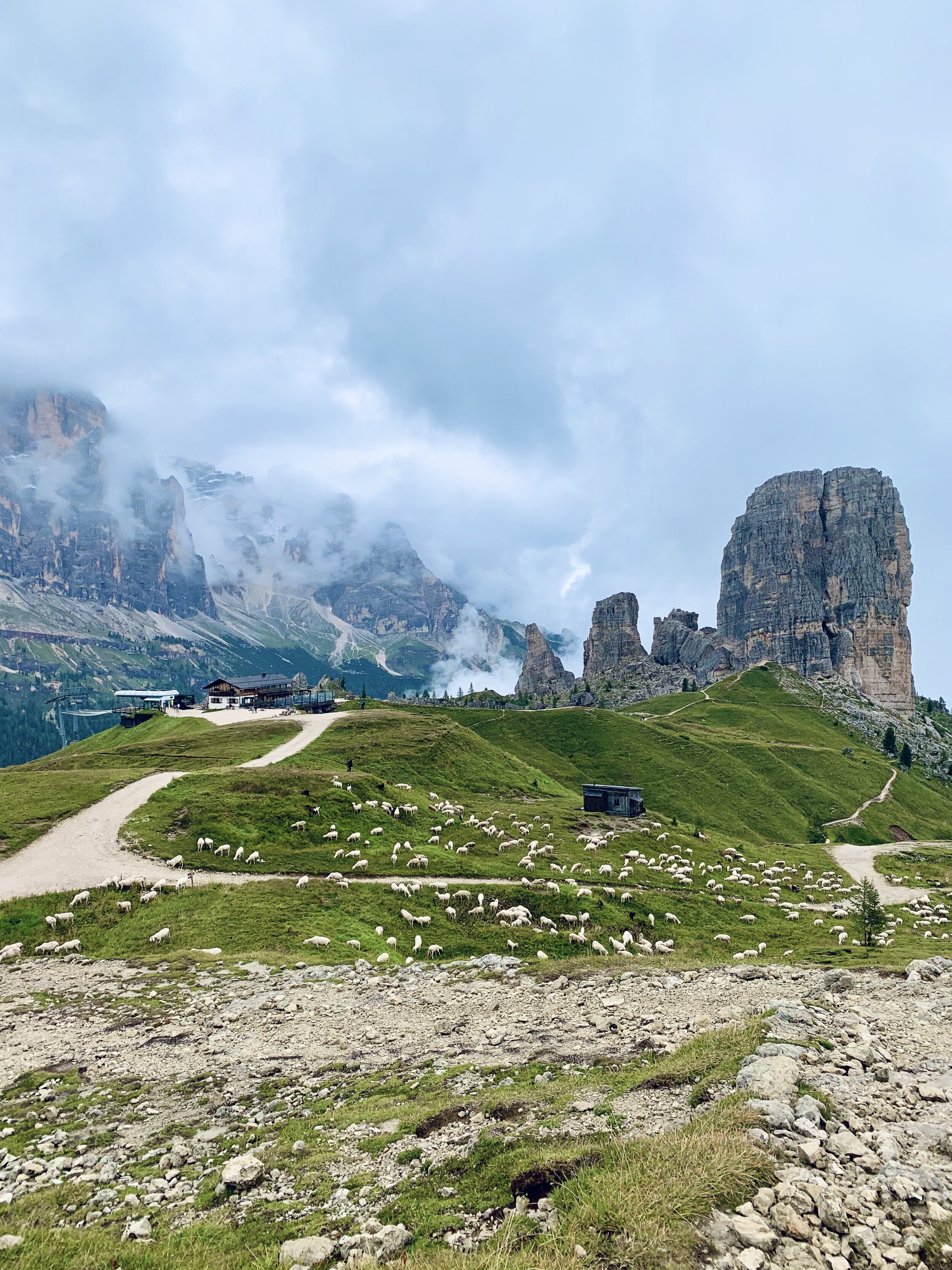
Sheeps in front of Cinque Torri
To reach the lake, we needed to hike up in the middle of two mountains, and Lucas pushed the tempo quite a bit, but it felt terrific to push myself after a long time being. From the peak, it was a fast downhill to Lago Bai de Dones, where we went in for a late lunch. We hiked back to our car and finished our day again with cheese and Apfelstrudel at the river with a view towards the mountain, put our legs into the cold water, and went for dinner in Cortina d’Ampezzo… these little things, so damn good.
Day 6: 10km, 300hm — Lago di Braies.
Our tour already came to an end, and we needed to drive 4–5h back to Munich but didn’t want to leave the Dolomites without going to Lago di Braies. Luckily the sun was up, and we hiked the 6km from the parking lot to the beautiful Lago di Braies that looks as Canadian as it can get in Italy. We took a few pics to show off (below is one), went around the lake, and used the sunny weather for a quick swim before we ran back to our car. Yes, my calve got much better due to all the movements, and it felt incredible to run a bit faster for a few kilometers again. We stopped at a local restaurant just before the parking lot for a proper Kaiserschmarren and then drove back to Munich.

Lake Louise or Lago di Braies? ;-)
I shouldn’t compare this trip to the years before, it’s an unfair comparison, and of course, it was less adventurous. But things are just very different this year due to Covid-19, and I feel very fortunate that I could spend a few days in the Dolomites — a place I always wanted to go.
